
Understanding Tropical Cyclone Track Maps
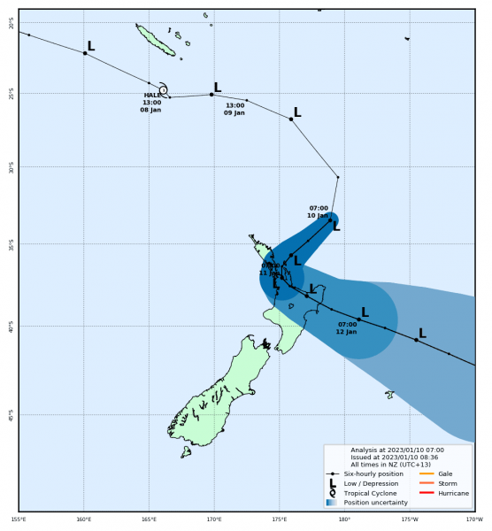
MetService issued track map of Cyclone Hale on 10 January 2023
Tropical Cyclone season for New Zealand runs from 1 November to 30 April. During this time, MetService issues track maps to show where a tropical cyclone has been and where it’s expected to go next.
Each map tells two stories: the past and the future.

Top half of a track map showing the path the cyclone has followed so far
The black line shows where the centre of the cyclone has already travelled. Dots mark its position every six hours, with Ls showing when it’s still a tropical low and numbers showing its strength once it’s a tropical cyclone. All times are given in New Zealand local time (UTC+12, but UTC+13 during daylight saving, which is most of tropical cyclone season).

Bottom half of the track map showing the forecast path, including the blue cone of uncertainty
Looking ahead, the blue cone shows where the centre of the cyclone might move. The black line down the middle is the best forecast path, but the system could be anywhere inside the cone. It is referred to as the “cone of uncertainty”, the lighter the blue, the greater the uncertainty of its exact path.
Remember, severe weather can happen well away from the centre; heavy rain, strong winds, and large waves can, and often do, reach far beyond that line.
MetService only issues these maps once a system moves into New Zealand’s area of responsibility. Before then, it’s tracked by other weather agencies, such as the Australian Bureau of Meteorology or Fiji Meteorological Service.
Tropical Cyclones get their energy from the warm waters of the tropics. As they move south over cooler seas, they lose that energy and encounter stronger winds higher in the atmosphere. Together, these changes affect the cyclone’s shape and structure, and it gradually transforms into an extra-tropical cyclone. It is no longer a tropical cyclone, but it can still bring severe weather to New Zealand. On the map, this change is shown when the cyclone symbol and number are replaced by an L.
Track maps are a great way to follow a cyclone’s journey, but they don’t show the full picture of impacts. For the latest warnings on wind, rain, and waves, keep an eye on the MetService Warnings page throughout the season.