
Severe Thunderstorms
Most of New Zealand’s severe weather comes from large systems like lows and fronts, which can affect wide areas for long periods. But some of our most intense weather, like very heavy rain, large hail, or even damaging winds, can come from something much smaller and shorter-lived: a severe thunderstorm.
Because thunderstorms are small, localised systems, they typically only affect a small area and often last for less than an hour. But their impact can be just as serious as that from larger systems, especially when it comes to flash flooding, hail damage, squally winds, or even tornadoes.
When and where do they happen?
Severe thunderstorms can happen anywhere in New Zealand, but some regions see them more often than others. In eastern and inland areas, they're most likely in the afternoons and evenings during spring and summer, when daytime heating builds up instability in the atmosphere. An “unstable“ atmosphere is what helps air rise to be able form clouds, rain and thunderstorms. In western parts of the country, though, they can happen at any time of year, even overnight or in winter.
How often do they occur?
Thunderstorms themselves are not unusual in New Zealand, especially in the west. But severe thunderstorms, which are intense enough to cause damage or disruption, are much less common. On average, they might only occur once a month or less. That means the chance of being directly under one is fairly low, but if you are, the risk can be high.
What makes a thunderstorm “severe”?
MetService defines a thunderstorm as severe if it produces at least one of the following:
Heavy rain of 25 mm per hour or more
Large hail with a diameter of 20 mm or more
Strong wind gusts of 110 km/h (60 knots) or more
A damaging tornado with wind speeds over 116 km/h (63 knots)
Some thunderstorms might also produce funnel clouds, waterspouts or small tornadoes, even if they don’t meet the criteria for a Severe Thunderstorm Warning.
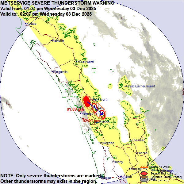
A Severe Thunderstorm Warning over Auckland with the current position in filled-in red, and the future position over the next hour in the open red circles (MetService, 2025)
How much notice is possible?
A Severe Thunderstorm Watch can be issued ahead of time (up to 24 hours in advance) when the risk for severe thunderstorms is high but the exact timing and location are still uncertain.
However, Severe Thunderstorm Warnings rely heavily on radar. Because thunderstorms are small scale and develop quickly, a Severe Thunderstorm Warning will often only be issued for areas likely to be affected once a storm is already happening and can be tracked on the radar. That might be about 30 minutes after it first formed. Warnings of severe thunderstorms will only be available within about 150 km of a weather radar because the amount and quality of data decreases with distance from a weather radar. So, if you receive a warning, the storm is already out there. Severe Thunderstorm Warnings are Red Warnings and indicate the need to act now to stay safe.
What can you do with short notice?
Even with less than an hour’s warning, there are some simple actions that can make a big difference:
Torrential rain: If you're in a narrow riverbed or stormwater drain, get out quickly to avoid flash flooding.
Strong winds: Secure anything outside that could blow away. If you’re on the roof or a ladder, get down immediately.
Lightning: Head indoors, avoid tall trees, and consider unplugging electronic devices.
Hail: If driving, slow down or pull over. If possible, move your car under cover.
Who issues the warnings?
Severe thunderstorm forecasts and warnings come from a dedicated group of experienced forecasters at MetService. Each day, they issue Severe Weather and Thunderstorm Outlooks, and they’re responsible for Watches and Warnings when the criteria are likely to be met.
What to do during and after the storm
NEMA (National Emergency Management Agency) and MetService recommend that people:
Take shelter indoors, away from windows
Avoid sheltering under trees
Move cars under cover or away from trees
Secure loose outdoor items
Check drains and gutters are clear
After the storm:
Be cautious of fallen trees and powerlines
Stay clear of flooded drains and streams as water levels can rise quickly and be dangerous