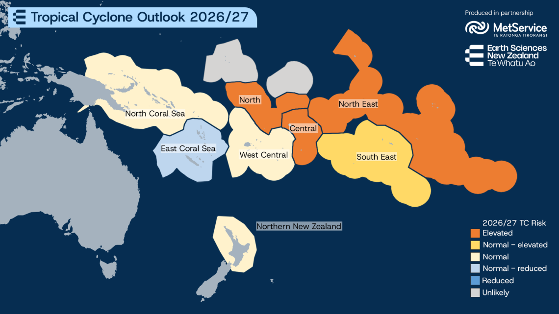
Southwest Pacific Tropical Cyclone Outlook 26/27
The Tropical Cyclone Season in the southern hemisphere begins next month and runs until April.
Every year MetService contributes to the Southwest Pacific Tropical Cyclone Outlook, which assess the seasons' cyclone risk. The Outlook which is coordinated by Earth Sciences New Zealand and developed with meteorological services from across the Pacific has just been released.
For New Zealand, the latest Outlook indicates that the tropical cyclone risk is expected to be near normal, with the greatest likelihood of ex-tropical cyclone impacts occurring during late summer and autumn. Northern and western parts of the country may have a higher chance of experiencing the remnants of tropical systems this season.
Across much of the Southwest Pacific, a strong El Niño is expected to contribute to normal to above-normal cyclone activity during the 2026/27 season, with 7 to 11 named tropical cyclones forecast and at least four expected to reach Category 3 intensity or higher.
As New Zealand's national weather authority, MetService monitors and forecasts tropical cyclones and ex-tropical cyclones that may affect New Zealand, while also supporting the provision of weather services across the Pacific. MetService operates the Tropical Cyclone Warning Centre (TCWC) Wellington, meaning all official warnings and information for tropical cyclones that have the potential to impact New Zealand are issued by us.
Find out more about how we monitor tropical cyclones: Tropical Cyclone Monitoring — About MetService
You can read the full outlook: Southwest Pacific Tropical Cyclone Outlook | Earth Sciences New Zealand | NIWA