
Meteorology for Aviation
Elevate safety and efficiency with MetService’s world-class weather solutions, tailored for the aviation industry.

Aviation safety and operational efficiency is profoundly impacted by weather.
As a Civil Aviation Authority PART 174 certified meteorological service organisation, MetService delivers world-class meteorological solutions across the full spectrum of aviation operators.
Our specialised aviation forecasters work 24/7 to monitor observations and produce forecasts that are essential for safety, operational continuity, and the protection of assets within the aviation sector.
Aviation Products

PreFlight Pro
The one-stop platform supporting commercial pilots throughout New Zealand.
Developed by Aeropath and MetService, Preflight provides a suite of benefits to the aviation sector through the delivery of safety-critical weather and aeronautical information.
Users can view SIGMETs and SIGWX charts as graphical layers on an interactive map, and click on aerodromes to view available METARs, TAFs, NOTAMs, procedural charts, and webcam images.
Custom briefings can also be created, saved and loaded to easily package the information required for a flight - equipping pilots with swift and efficient access to critical insights.
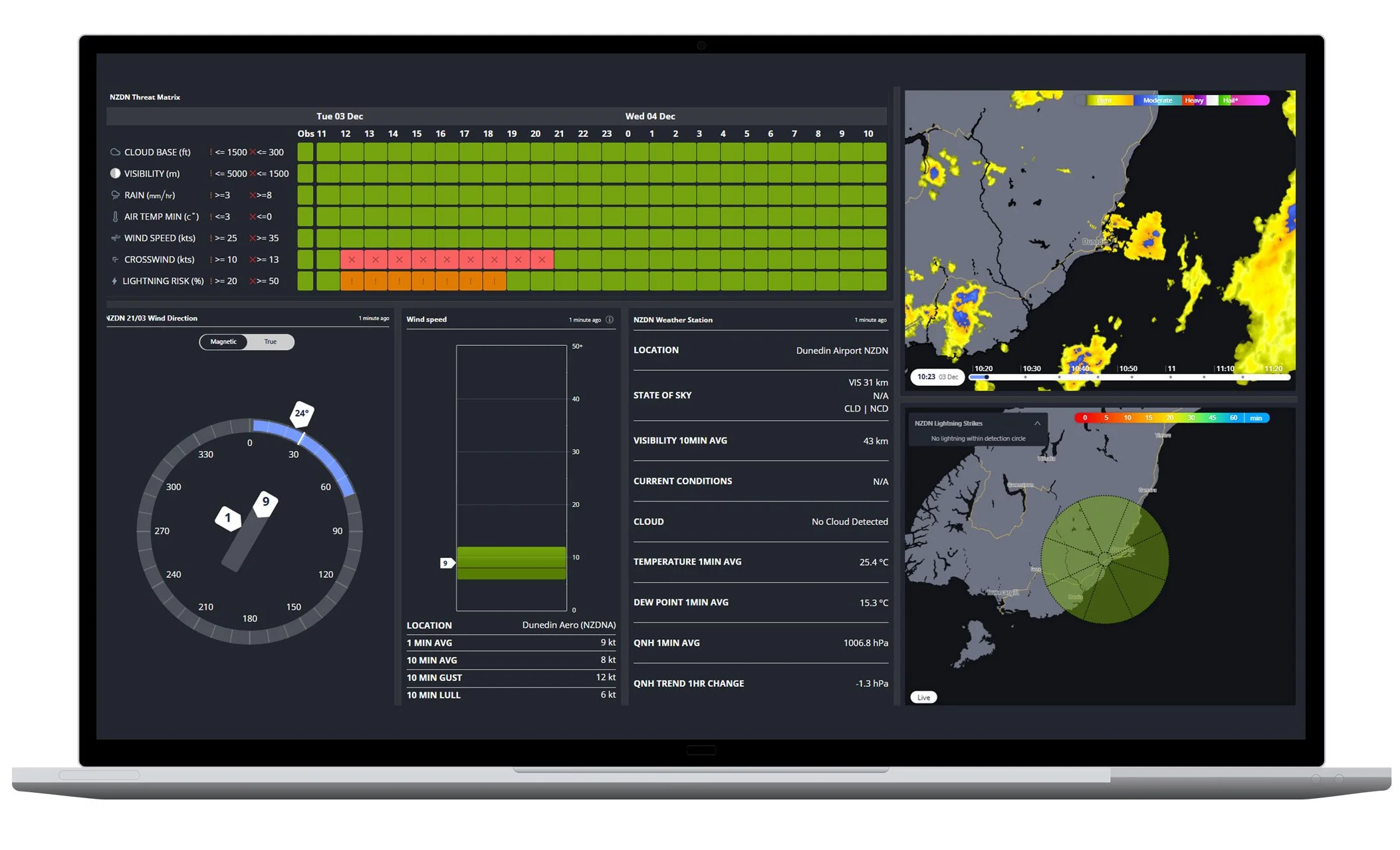
Aviation Dashboards
Elevate your situational awareness of weather threats through your own informative dashboard.
Displaying just as well on the large screens of an operation centre as they do on your mobile, our Aviation Dashboards can be customised to include any number of widgets - each rich with the meteorological observations and forecasts pertinent to your operation. Aviation Dashboards are configured to your specific needs - enabling smarter, data-driven decisions. Our aviation weather widgets include:
Airport Threat Matrix: An Airport Threat Matrix provides a clear picture of the state of play both now and over your chosen time period. Using METAR, TAF, and model data, the matrix depicts relevant weather threats using components and thresholds chosen by you.
1-Minute Data Widgets: Runway Dials, Wind Speed Bars, and Automatic Weather Station read-outs provide a snapshot of the latest observations at an airport. Updating every few minutes, these widgets show the latest wind speeds, direction, gusts/lulls, visibility, cloud, temperature, pressure and the state of the sky.
Lightning and Radar Widgets: View real-time lightning strikes and details at any NZ location. Add custom watch and warning rings to highlight strikes within set ranges, overlay lightning data with radar imagery to track active cells, and use the optional lightning prediction layer to identify areas at risk of future strikes.