
Tropical Cyclone Monitoring
The World Meteorological Organization (WMO) Tropical Cyclone Programme has been established to minimise the loss of life and damage caused by tropical cyclones.
Who is Watching for Tropical Cyclones?
Internationally there are six Regional Specialised Meteorological Centres (RSMCs), together with six Tropical Cyclone Warning Centres (TCWCs), which have regional responsibility to provide tropical cyclone warnings and information.
MetService operates TCWC Wellington, so all official warnings and information about tropical cyclones that could affect New Zealand originate from us.
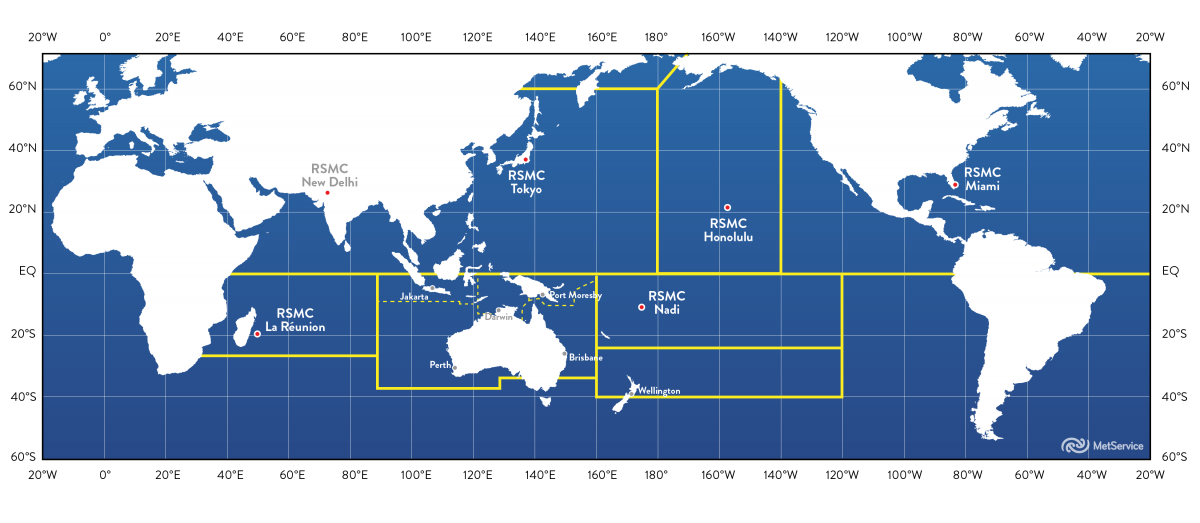
Map of WMO Tropical Cyclone Monitoring Centres
What is a Tropical Cyclone?
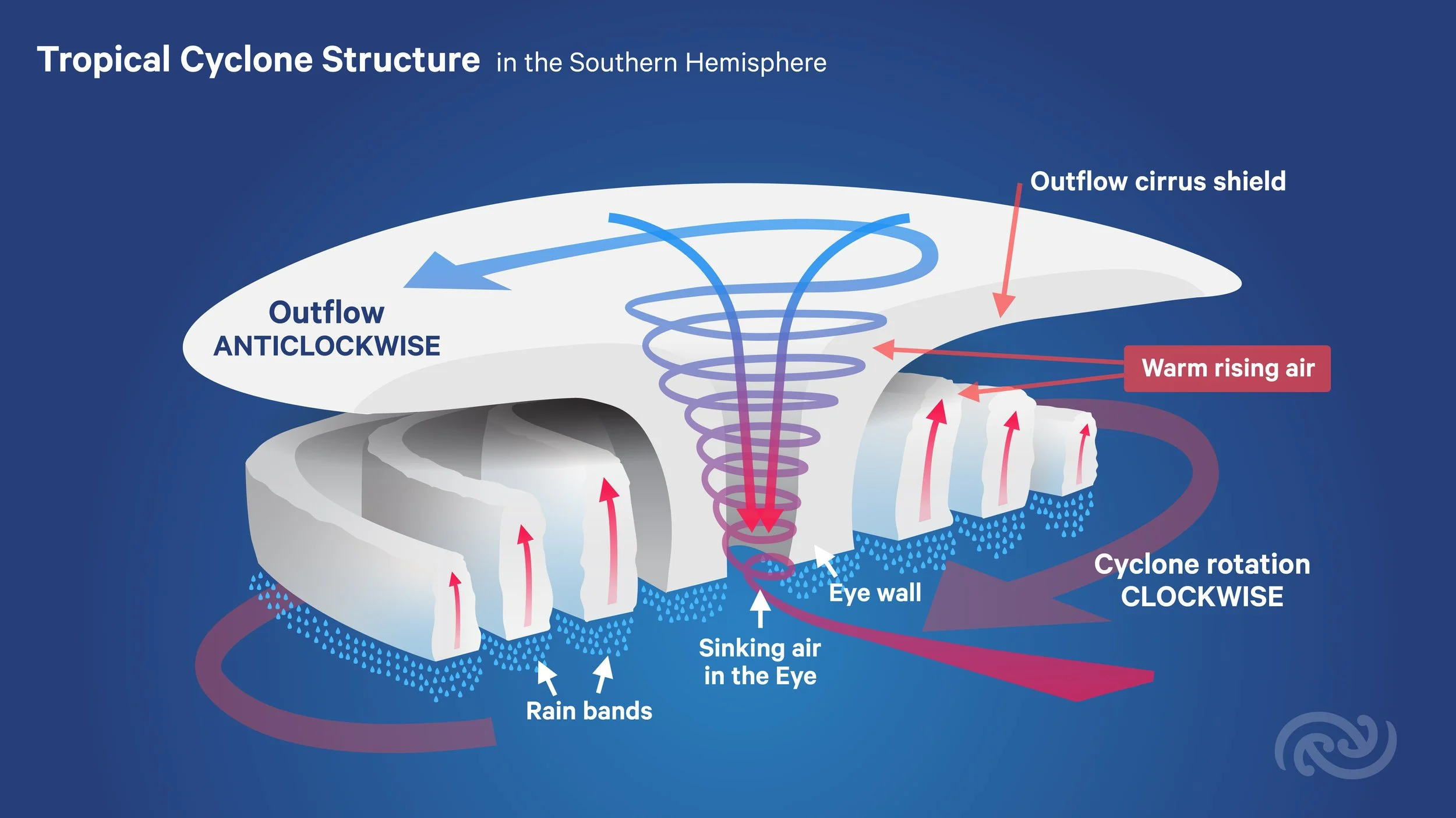
A tropical cyclone is a low pressure system which forms over warm waters in the Tropics and has gale force winds (63km/h or more) at low levels near the centre (winds turning clockwise in the Southern Hemisphere), with organised convection (i.e. thunderstorm activity). The diagram below shows the structure of a tropical cyclone in the Southern Hemisphere.
The gale force winds around the cyclone can spread out hundreds of kilometers from the centre or eye of the cyclone, and if the winds reach 64 knots (118km/h) then the system is called a severe tropical cyclone.
Severe tropical cyclones are named differently in other parts of the world. Here in the South Pacific and Australia they are known as Severe Tropical Cyclones, in the Northwest Pacific they are called Typhoons and in the North Atlantic and Northeast Pacific they are called Hurricanes.
When do we get Tropical Cyclones?
In the Southern Hemisphere, the tropical cyclone season usually lasts from November to April, with a peak in February. In the Northern Hemisphere, most tropical cyclones occur between June and November with a peak in September. However, in the north-west Pacific it is not unusual to have the occasional tropical cyclone outside of this period. Tropical cyclones have been observed in the South Atlantic, but this is a very rare occurrence.

Worldwide map of all tropical cyclone tracks between 1985 and 2005 – courtesy Wikimedia Commons.
What are the different categories of Tropical Cyclone?
This table outlines how Tropical Cyclones are categorised under the Australian tropical cyclone intensity scale used by the Fiji Meteorological Service and the Australian Bureau of Meteorology (any tropical cyclones that impact New Zealand originate from these regions, and are no longer 'tropical' when they reach us).
| Category | Known as |
10-minute Mean Wind Speed
|
Maximum 3-second Gust Speed
|
|---|---|---|---|
| 1 | Tropical Cyclone | 34-47 knots (63-87 km/h) | Less than 125 km/h |
| 2 | Tropical Cyclone | 48-63 knots (89-117 km/h) | 125-164 km/h (Destructive winds) |
| 3 | Severe Tropical Cyclone | 64-85 knots (119-157 km/h) | 165-224 km/h (Very destructive winds) |
| 4 | Severe Tropical Cyclone | 86-107 knots (159-198 km/h) | 225-279 km/h (Very destructive winds) |
| 5 | Severe Tropical Cyclone |
Over 107 knots (Over 200 km/h)
|
Over 280 km/h (Very destructive winds) |
Facts about Tropical Cyclones and New Zealand
On average, about 10 tropical cyclones form in the South Pacific tropics between November and April each year, and about one of those will affect New Zealand as an ex-tropical cyclone (most commonly in February or March).
The characteristics and structure of any tropical cyclone will change dramatically by the time it reaches New Zealand, and it will almost certainly be re-classified as an ex-tropical cyclone. This is due to it moving over colder waters and encountering strong upper level winds as it moves south out of the tropics. See our blog Tropical cyclones: extra-tropical transition for more information about extra-tropical transition. Although these systems will no longer be classified as tropical cyclones, we will often still refer to them by their given name e.g. ‘Cyclone Gita' for communication purposes.
Re-classification as an ex-tropical cyclone does not necessarily mean the system has weakened, but rather that it has transformed into a completely different type of weather system. Ex-tropical cyclones may still have considerable potential for severe weather, and under the right meteorological conditions they can intensify and acquire lower pressures than they had before being re-classified. Many of New Zealand’s most severe and impactful storms have been ex-tropical cyclones.
In the tropics, the strongest winds and most intense rain associated with a tropical cyclone usually occur just outside the ‘eye’ (cyclone centre). However, after the cyclone has undergone extra-tropical transition, it loses its symmetric cloud pattern and the strongest winds and heaviest rain can be hundreds of kilometres from the cyclone's centre, usually in a large area south of the centre. This means that the position of the cyclone centre is no longer a good indicator of where the most severe weather will be. For example, During Cyclone Bola in 1988, the heaviest rain and strongest winds over New Zealand occurred well away from the centre of the cyclone. It is wrong to assume that because the cyclone centre is missing New Zealand, the severe weather will also miss New Zealand!