Frost
In the bud-setting season, frost is an enemy. If the air is cold, calm and dry enough, and the sky is clear enough, your crops will radiate their heat to the night sky and keep cooling until they hit the dew point. If the dew point is below zero, even before sunset, then that is a pretty good indicator that a frosty night is coming.
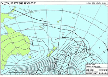
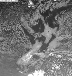
6am on 6th June 2006 (6-6-6). The devil number and frost bedevils us with a six degree ground frost at Henderson in west Auckland. Satellite image and map from MetService.
The satellite picture and weather map on right show a typical winter frosty morning in New Zealand. Note that the “cold southwesterly” isobars over New Zealand only need to space themselves apart a little bit to form the light winds and clear skies that make it frosty.
There are many terms used to measure frost, and it can be confusing to a beginner, so here is a run down of the various terms and what they measure.
Overnight low
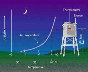
A typical MetService forecast as seen on TV, heard on the radio or read in the paper will tell you about the overnight low. This is the lowest that the air temperature is expected to get at about shoulder height. This air temperature is measured in a special screen (called a Stevenson screen) and at a specific height (1.3 metres or 4.3 feet) above ground level. The screen is designed to allow the temperature probe to reach equilibrium with air temperature inside - it shields against rain and warming /cooling by radiation and allows free air flow. The first such screen was designed by Robert Louis Stevenson's father Thomas Stevenson (1818-1887).
Note that the OVERNIGHT LOW is for an AIR temperature and not a ground temperature.
When this temperature drops below zero we say there is an air frost. Sometimes in autumn, when the sail is warm, a cold southerly can bring a air frost even when the ground stays above freezing. Normally the ground is significantly colder, as shown in this diagram.
Rapid change of temperature with height near the ground on a frosty night. Your toes get colder than your nose.
This diagram of a Stevenson screen shows that temperature near the ground may be as much as four degrees Celsius cooler than the overnight low. This also helps explain why the overnight low normally reaches it lowest point about half-an-hour AFTER sunrise. The first rays of sunlight warm the ground and stir up the coldest air, spreading it upwards.
Ground Frost
The ground is always losing heat by radiation, but during the day this is more than compensated for by warmth from incoming sunlight. At night the ground cools and acts like the cooling panel in a fridge, cooling the air above it. Clouds and wind help to reduce this heat loss, but if it is clear and calm and the night is long, and the previous day is cold enough, then the ground temperature will drop below zero.
The standard method for measuring frost is the Grass Minimum Temperature. This is measured by an unshielded temperature probe horizontally mounted 25 to 30mm above a clipped grass surface (flat lawn). When this reaches or drops below -1deg;C we say a ground frost has occurred, and the number of degrees of frost refers to how far the grass minimum reading gets below zero. So a minus two Celsius grass minimum temperature is taken as two degrees of frost. Technically you can not have half a degree of frost. In the UK the frost threshold is -0.9deg;C or 30.4deg;F. NIWA's tables of days of ground frosts as at http://www.niwascience.co.nz/edu/resources/climate/groundfrost/ are based on the standard -1°C threshold
| Severity of Ground Frost | Degrees Celsius |
|---|---|
| Slight | between -1deg; to -3deg; |
| Moderate | between -3deg; and -6deg; |
| Severe | between -6° and -9° |
| Very severe | below-9deg; |
Ground Frost is a better parameter than the overnight low for measuring, reporting, and comparing frosts, but when it comes to working out what is happening to your crops it still doesn't give the full story. Your crops do not have the luxury of a radiation shield and they lose heat to outer-space FASTER THAN THE AIR. In fact it is the crops and ground that cool the air, not the other way round. Even when the overnight low is plus 2degC you might find ice forming on your car windscreen, and there is also a good chance that your crops a metre above the ground could be 1deg to 2degC COLDER than the overnight low, and the ground (and ground crops such as strawberries) could be 2deg to 4degC below.
Types of frost
|
|
|
|
|
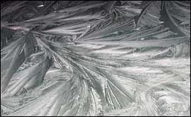
Black Frost
|
|
|
|
|
|
|
|
Advection Frost “When there is snow on the mountains, you can get frost in the plains. Advection frost occurs when sub-zero air drifts over your location from somewhere else. In New Zealand the main source of a sub-zero air mass is drainage from mountain snow. Unlike a normal radiation frost, it works from the top of the plant downwards. |
|
Inversion Strength
Air normally cools off aloft as it thins. On a frosty night the coldest air is near the ground and the layer of chilled air that hugs the ground has a temperature change with height that is inverted from the norm. The top of this layer is referred to as the level of the nocturnal inversion, and is usually found around 20 to 30 metres above the ground, sometimes as high as 100m. The strength of the nocturnal inversion depends on how shallow this layer is and how warm the unchilled air is. Wind machines and choppers draw air downwards from this level and if it warm enough it will help prevent frost in the crops. A strong nocturnal inversion has air that is more than 4degC warmer within reach. If the air aloft was already cold before sunset, or has recently drifted over some snow as in an advection frost, then the inversion is weak, maybe 2degC or less, and that is when wind machines and choppers may be ineffective. |
 Window frost (and sometimes fern frost)
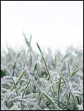 White Frost
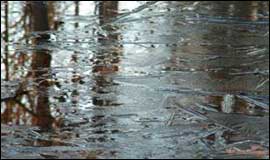 Black Ice
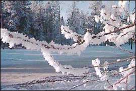 Hoar Frost
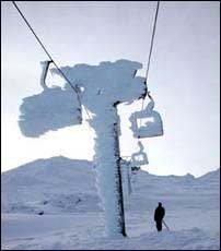 Rime Ice
Estimating your frost
A frost forecast requires the application of or our winning formula 1. Get the best idea of what’s coming next (from MetService), then 2: Fine-tune this to your own location.
Here are a few frost forecasting methods;
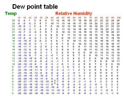
1. Measure your dew point. This is the temperature at which water vapour starts condensing (dew forms). The dew point that is measured around 3pm can be taken as a useful first-estimate of the overnight low, for those nights with no air-mass change. The air temperature can be expected to cool to this value (or lower) on a clear calm long night.
There are not many devices around that can directly measure dew point. One way is to measure the wet bulb temperature and then use tables. An easier way is to measure RELATIVE HUMIDITY RH (with a hygrometer- these are cheap and plentiful) and then use the following table. Hygrometers are usually least accurate when the RH is around 50% but give good readings when RH is above 80% or below 30%. Remember to keep the RH probe outside, and if you wish to measure the air temperature at the same time then use a thermometer that is properly housed in a Stevenson screen.
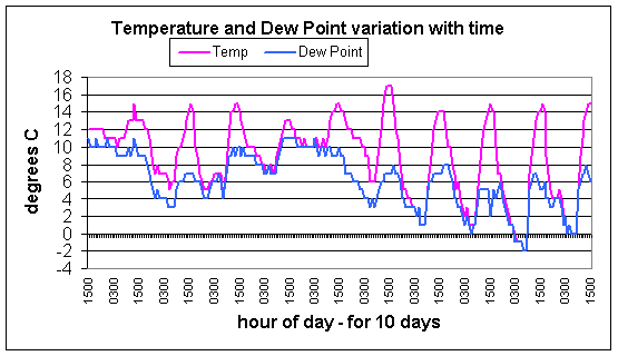
So for example with a 3pm temperature of 11degC and a 50% Relative Humidity this means a dew point of 1degC. Deducting 4 degrees from an estimated overnight low of 1degC gives an estimated ground minimum temperature of -3degC, and that is a moderate frost which can be damaging in spring. BEWARE: This method gives just an initial idea and may need more fine-tuning the final overnight low can get lower. Once the dew point is reached there may be some further cooling on a calm clear night longer than 12 hours and then the air temperature and dew point may fall in tandem, as this graph shows (below right.)
2. Use an empirical formula. There are many around. A former New Zealand Meteorological Service Chief Meteorologist, Ray Smith, wrote a Technical Note (#217) in 1973 researching an empirical formula for forecasting the ground minimum in Canterbury on clear calm spring nights:
Tg = 0.3 x (T + Td/2)
Where Tg is the forecast ground frost for tomorrow morning in degC
T is the 3pm air temperature in degC
Td is the 3pm dew point in degC
And c is usually 8 degrees (but in Canterbury in winter it is closer to 9 degrees).
So, as above, if it is 11degC at 3pm and RH is 50% then Tg is 0.3 *(11+1/2)-8 or around -4.55°C. This calculation can be considered to be a fine-tuning of method 1.
A reference to this formula is made on the NZ Wine Society web page at http://www.nzwine.com/assets/frost_review.pdf see Section 3.3, page 15.
Method 3. Extrapolate the changing temperature during the night. Once the night has set in and the temperature has started falling it tends to only fall at a rate determined by Newton's law of cooling. Bill Ireland (www.frostandcrops.com) has produced graphical overlays which you can use soon after sunset to get an accurate estimate for your morning ground frost, and one that you can update at any time if conditions change.
Method 4. Be forewarned. The amount of frost that occurs varies a lot from paddock to paddock and even within a paddock, so if you can build up some local knowledge of how your place varies in comparison with one of the MetService monitored sites, then we can help:
So get out there and start measuring and use these techniques to help forecast your overnight frost.